Lava flows on Olympus Mons probably melted ice in the ground, making the volcano flank unstable; rockfalls and landslides moved hundreds of km into the surrounding landscape, forming a characteristic ‘wrinkled’ landscape there; today, steep escarpments form the base of Olympus Mons, exposing its 600-km-wide ‘plinth.’
Mars is home to the largest volcanoes in the Solar System. The tallest of these is Olympus Mons, a giant shield volcano spotted in 1971 by NASA’s Mariner 9 spacecraft.
Olympus Mons is 21.9 km tall at its peak, about 2.5 times higher than Earth’s Mount Everest rises above sea level.
Mariner scientists spied not just Olympus Mons’ peak but also its surroundings, noticing an ‘aureole’ spreading out from the volcano’s base for hundreds of km.
This aureole in turn surrounds the volcano’s ‘basal scarp’, an immediate perimeter around Olympus Mons that is remarkably steep, hitting seven km tall in some places.
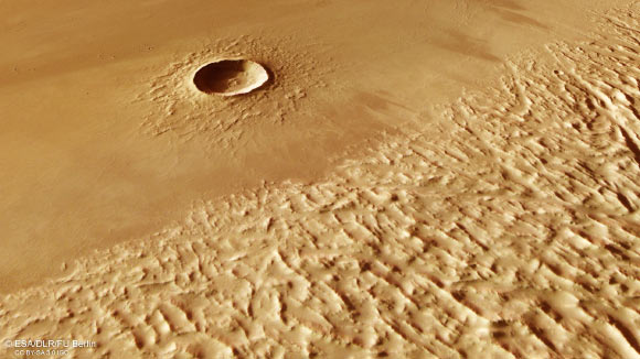
The new images from the High Resolution Stereo Camera (HRSC) on ESA’s Mars Express show a crumpled feature named Lycus Sulci, on the edges of the aureole; the volcano itself is located out of frame to the bottom left (south-east), many hundreds of km away.
The aureole tells the story of how Olympus Mons’ lower flanks catastrophically collapsed several 100 million years ago.
Large amounts of lava once flowed down the volcano, triggering landslides that tumbled down its flanks to meet bedrock — in this case, bedrock containing ice and water.
The swelteringly hot lava caused this ice to melt and become unstable; as a result, the rocky rim of Olympus Mons broke off and partially slid away.
This collapse came in the form of huge rockfalls and landslides, which slipped downwards and spread widely across the surrounding plains.
As the landslides moved away from Olympus Mons and traveled across the Martian surface they became alternately compressed and stretched — crumpled and pulled apart.
This created the characteristic…
Read the full article here


