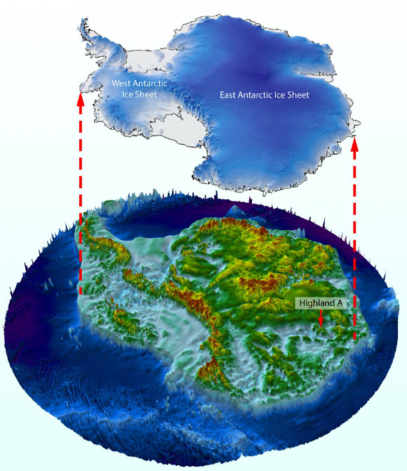
Geoscientists from Durham University and elsewhere have discovered a landscape that appears to have been formed by rivers at least 14 million years ago and possibly even before the initial growth of the East Antarctic ice around 34 million years ago.
The Earth’s climate is rapidly changing and is on course to reach temperatures typical of those 34-14 million years ago (between 3-7 degrees Celsius higher than today).
Understanding how the Antarctic Ice Sheet changed in the past helps inform how it may evolve in the future owing to ongoing climate change.
This is important because the ice sheet currently contains the equivalent of approximately 60 m of potential sea level rise.
Ice-penetrating radar can be used to see the landscape underneath the ice and determine how the ice sheet changed before the satellite era.
“The land underneath the East Antarctic Ice Sheet is less well known than the surface of Mars,” said Durham University’s Professor Stewart Jamieson.
“And that’s a problem because that landscape controls the way that ice in Antarctica flows, and it controls the way it might respond to past, present and future climate change.”
“So, we’re investigating a small part of that landscape in more detail to see what it can tell us about the evolution of the landscape and the evolution of the ice sheet.”
“And what we find is an ancient land surface that has not been eroded by the ice sheet and instead it looks like it was created by rivers before the ice came along.”
“This tells us that there hasn’t been a lot of change in this particular area, which indicates that although this part of the ice sheet may have retreated during warmer times in the past, the conditions at this site likely did not change much, and that helps us understand how the ice sheet might respond to future and ongoing warming.”
Professor Jamieson and his colleagues used satellites and radar to analyze the landscape underneath the East Antarctic Ice Sheet in the…
Read the full article here


