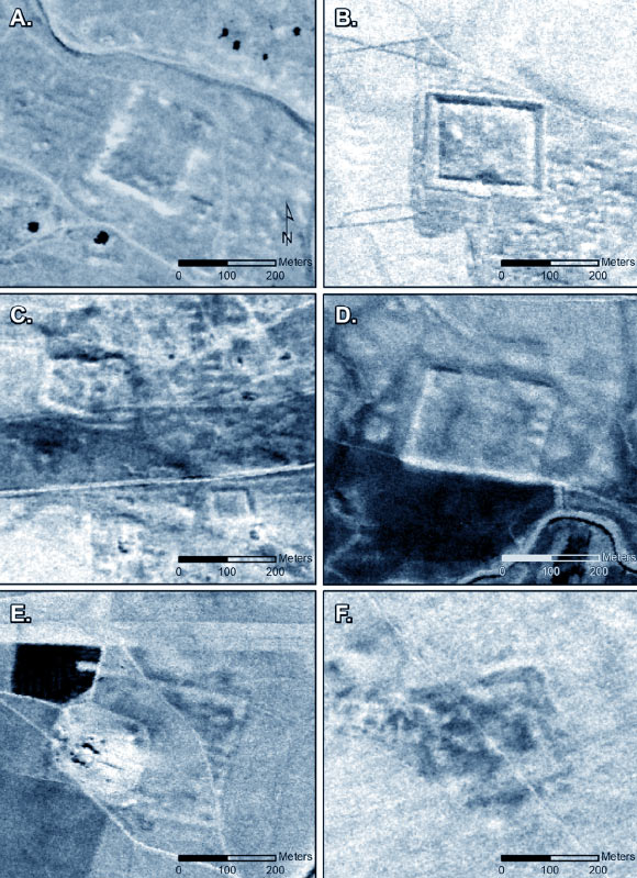
During a pioneering aerial survey of the Near East in the 1920s, the Jesuit French priest Father Antoine Poidebard recorded 116 fortified military buildings that traced the eastern frontier of the Roman Empire. Based on their distribution, Poidebard proposed that these forts represented a line of defense against incursions from the east. Using declassified images from the CORONA and HEXAGON spy satellite programs, archaeologists have now identified a further 396 ancient forts widely distributed across the northern Fertile Crescent, spanning from what is now western Syria to northwestern Iraq. The spatial distribution of the forts the authors have mapped no longer supports Poidebard’s central thesis that they constituted a broadly north-south line along the eastern boundary of the Roman Empire.
In the 1920s, at the beginning of the ‘age of aviation,’ Father Antoine Poidebard undertook one of the world’s first aerial archaeological surveys, using a biplane and a camera to document hundreds of ancient forts and other sites throughout what today is Syria, Iraq and Jordan.
Having piloted a biplane during the First World War, Poidebard later became a priest at Université Saint-Joseph in Beirut and joined the 39th Aviation Regiment of the French Levant forces, through which he began his expansive aerial survey of desert regions.
Although today Poidebard is remembered primarily for his technological innovation in using aerial photography as an archaeological survey tool, an achievement that also fascinated his contemporaries, the substance of his investigation was based on mapping Roman-period forts and defensive installations along the eastern periphery of the empire.
In his magisterial monograph, Poidebard presented hundreds of previously unknown forts and other sites over an area that stretches more than 1,000 km along the Roman frontier or limes.
Poidebard reported that the forts were constructed from north to south to establish an eastern boundary of…
Read the full article here


