New images from the High Resolution Stereo Camera (HRSC) on ESA’s Mars Express spacecraft show the terrain surrounding the permanent north polar ice cap of Mars.
Mars’ permanent north polar ice cap is a stack of water ice and dust layers up to 3 km thick and approximately 1,000 km in diameter.
These are divided into four stacked ‘packets’ of different thicknesses, which in turn are made up of finer layers.
These layers contain information about the climate dating back several million years in the history of Mars.
The deposits were formed by atmospheric precipitation of dust and water ice and by direct frost formation.
They consist mainly of water ice, with fine dust sediments making up between 10 and 15% of the total.
They probably reflect changes in the orbit of Mars and the inclination of the planet’s axis of rotation, whose orientation is much more unstable than that of the Earth.
It varies in several cycles with periods ranging from a few thousand to a few million years.
The varying solar radiation results in a strongly varying climate, especially at the poles. It is assumed that the north polar ice cap is currently growing.
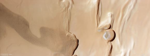
“The terrain surrounding Mars’ north pole, known as Planum Boreum, is fascinating,” said members of the Mars Express team.
“The pole itself is covered in layers and layers of fine dust and water ice; these stack several km thick and stretch out for around 1,000 km.”
“While most of this material is not visible here, you can see the beginnings of Planum Boreum to the right of the frame, with some subtle wrinkling showing where layers of material are starting to build up.”
“Ground has also built up more starkly in steps, as is most clearly visible in the topographic view of this region below.”
“The lowest altitude regions are blue/green and the highest are red/white/brown.”
“These layers formed as a mix of dust, water ice and frost settled on the Martian ground over time.”
“Each layer holds valuable…
Read the full article here


