August 13, 2024
3 min read
Will This Storm Become a Hurricane? Here’s How Meteorologists Tell
New techniques are helping forecasters spot storms that could develop into dangerous hurricanes earlier than ever
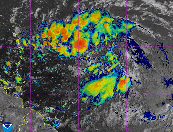
On August 12, 2024, forecasters were watching for signs that Potential Tropical Cyclone Five would develop into a hurricane. Later that day, it became Tropical Storm Ernesto and was forecast to become a hurricane later in the week.
NOAA/NESDIS/STAR – GOES-East
The following essay is reprinted with permission from ![]() The Conversation, an online publication covering the latest research.
The Conversation, an online publication covering the latest research.
When tropical meteorologists peer at satellite images, they often catch sight of subtle cloud formations hinting at something more ominous brewing.
The first signs of a potential hurricane can be detected days before a storm gains its fierce momentum. Wispy cirrus clouds radiating outward, the appearance of curved banding low-level clouds and a drop in atmospheric pressure are all clues.
On supporting science journalism
If you’re enjoying this article, consider supporting our award-winning journalism by subscribing. By purchasing a subscription you are helping to ensure the future of impactful stories about the discoveries and ideas shaping our world today.
These early clues are crucial for predicting the onset of what might develop into a catastrophic hurricane.
I am a meteorology professor at Penn State, and my research group uses satellites and computer models to improve forecasting of tropical weather systems. With an especially fierce Atlantic storm season forecast for 2024, being able to detect these initial signals and provide early warnings is more important than ever. Here’s what forecasters look for.
Conditions ripe for a hurricane
Hurricanes typically start as atmospheric tropical waves, areas of low pressure associated with clusters of thunderstorms. As these tropical waves move westward across tropical oceans, some of them can develop into…
Read the full article here


