The newly-discovered Roman road network system privileged the movement of animal-drawn wheel vehicles and is possibly the result of an evolutionary model, integrating pre-existing Prehistoric routeways with Roman military and civilian roads, most of which were probably still in use in Medieval times.
The wide-reaching, convincing network of Roman roads spanned the counties of Devon and Cornwall and connected significant settlements with military forts across the two counties as well as wider Britannia.
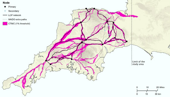
“Despite more than 70 years of scholarship, published maps of the Roman road network in southern Britain have remained largely unchanged and all are consistent in showing that west of Exeter, Roman Isca, there was little solid evidence for a system of long-distance roads,” said University of Exeter archaeologist Christopher Smart.
“But the recent availability of seamless LiDAR coverage for Britain has provided the means to transform our understanding of the Roman road network that developed within the province, and nowhere more so than in the far south western counties, in the territory of the Dumnonii.”
Dr. Smart and colleagues discovered the road network using laser scans collected as part of the Environment Agency’s National LiDAR Programme.
They then used sophisticated geographical modeling techniques to map out the full extent of the network and begin to understand the rationale for its existence.
“In terms of chronology, it is likely that the proposed network is an amalgam of pre-existing Prehistoric routeways, Roman military campaign roads or ‘tactical roads’ formally adopted into the provincial communications system, and of those constructed during peacetime in a wholly civilian context,” said University of Exeter archaeologist João Fonte.
“This evolutionary model is supported by the fact that the network does not solely connect Roman forts and their hinterlands directly, which are often connected by branch roads, but instead…
Read the full article here


