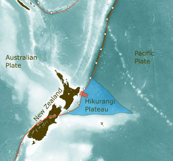
Revealed by 3D seismic imaging, the newly-discovered water reservoir lies 3.2 km (2 miles) under the ocean floor off the coast of New Zealand, where it may be dampening a major earthquake fault that faces the country’s North Island. The fault is known for producing slow-motion earthquakes, called slow slip events. These can release pent-up tectonic pressure harmlessly over days and weeks.
“Many slow slip earthquakes are thought to be linked to buried water,” said Dr. Andrew Gase, a postdoctoral researcher at the University of Texas.
“However, until now there was no direct geologic evidence to suggest such a large water reservoir existed at this particular New Zealand fault.”
“We can’t yet see deep enough to know exactly the effect on the fault, but we can see that the amount of water that’s going down here is actually much higher than normal.”
The site where Dr. Gase and colleagues found the water is part of a vast volcanic province that formed when a plume of lava the size of the United States breached the Earth’s surface in the Pacific Ocean 125 million years ago.
The event was one of the Earth’s largest known volcanic eruptions and rumbled on for several million years.
The study authors used seismic scans to build a 3D picture of the ancient volcanic plateau in which they saw thick, layered sediments surrounding buried volcanoes.
They ran lab experiments on drill core samples of the volcanic rock and found that water made up nearly half of its volume.
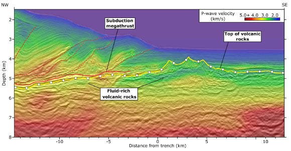
“Normal ocean crust, once it gets to be about 7 or 10 million years old should contain much less water,” Dr. Gase said.
“The ocean crust in the seismic scans was ten times as old, but it had remained much wetter.”
“The shallow seas where the eruptions took place eroded some of the volcanoes into a porous, broken-up rock that stored water like an aquifer as it was buried. Over time, the rock and rock fragments transformed into clay, locking in even more water.”
The finding…
Read the full article here


