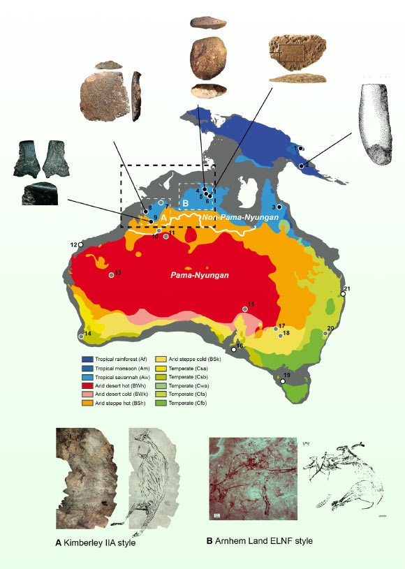
The new-submerged Northwest Shelf of Sahul — the combined landmass of Australia and New Guinea at times of lower sea level — was a vast area of land in the Late Pleistocene epoch that connected the Australian regions of the Kimberley and western Arnhem Land during times of lower sea level than today.
For the majority of the last 65,000 years of human history in Australia, lower sea levels revealed a vast expanse of dry land in the northwest of the continent, connecting the Kimberley and Arnhem Land into a contiguous area.
Through meticulous analysis of high-resolution bathymetric data, Griffith University researcher Kasih Norman and colleagues found that this Northwest Shelf, now submerged, existed as an extensive archipelago during Marine Isotope Stage 4 (71,000-59,000 years ago), which remained stable for 9,000 years.
This transformed into a fully exposed shelf in Marine Isotope Stage 2 (29,000-14,000 years ago), featuring an inland sea adjacent to a sizable freshwater lake, encircled by high escarpments cut by deep gorges.
The team’s demographic modeling indicates that the Northwest Shelf experienced fluctuating potential carrying capacities through Marine Isotope Stages 4-2, potentially supporting populations ranging from 50,000 to 500,000 people at various times.
However, rapid global sea level rises between 14,500-14,100 years ago (during Meltwater Pulse 1A) and between 12,000 and 9,000 years ago resulted in the rapid inundation of approximately 50% of the Northwest Shelf, causing profound changes in the space of human life spans.
These events likely triggered the retreat of human populations ahead of the encroaching coastline, evident in peaks of occupational intensity at archaeological sites across the Kimberley and Arnhem, and the sudden appearance of distinctive new rock art styles in both regions.
“The presence of this extensive archipelago likely facilitated the successful dispersal of the first maritime explorers from Wallacea — the…
Read the full article here


